

Ringsted Oplevelsessti & Køge Å-stien
Explore 50 kilometers of forests, lakes, meadows and quiet solitude only an hour by train and bus from central Copenhagen!
All you need before hiking
Learn more about the Ringsted Oplevelsessti (Ringsted Adventure Trail) and/or the Køge Å-stien (Stream of Køge Trail). From essential tips to downloadable GPX files; it’s all right here. Or maybe just dive into my 2025 blog packed with stunning photos. Or better yet, join me on the trail by watching my hiking video on YouTube.
Should YOU hike the trail?
Of course, you should. The alternating views of rural countryside and deep forest combined with ice age geological goodness is not to be missed. And believe it or not, the trail is mostly a hidden gem with only the occasional dog walker or day-hiker.

I strongly recommend the Ringsted Adventure Trail for two lovely days of leisurely trekking – or cut it in half, and do it in one day getting off halfway to take the train back from Borup which is half way.

- GPX-file for going from Køge to Ringsted (East to West)
- GPX-file for going from Ringsted to Køge (West to East)
Getting to the trailhead and back
The following is based on starting from Copenhagen and using public transportation. Generally, there is no point in going by car, but if you must, you could park in either end (for a fee) and get back to the starting point by way of bus. Anyway, here are the detailed directions for getting from central Copenhagen to either starting town and back.
If you have a Danish Travelcard, you can use it for both bus, train and S-train. Otherwise, a one-way ticket can be bought on any station using most credit cards or cash. Don’t board the train or bus without a ticket – you cannot acquire a ticket on board and controls are frequent with heavy fines for non-ticket-holders. When taking the bus to/from the Ringsted trailhead, you CAN in fact purchase a ticket from the driver, but you will need cash in fairly small denominations.
Bus and train service is frequent during daytime. The price is around 120 kroner (16 euros) for the train+bus trip between Copenhagen and Ringsted, while the S-train trip between Copenhagen and the west point at Køge will set you back around 60 kroner (8 euros). Less in both cases if you are using a Danish Travelcard.


Going EAST TO WEST you will want to grab a S-train (line A towards Køge) from any central Copenhagen S-train station to the terminus in Køge. It is roughly a 50-minute ride. Then walk 1,3 km. north-west to the eastern trailhead which is at this adress:
Ølbyvej 16, 4600 Køge (opposite side of the street)
GPS-coordinates for the start point, which can be used with Google Maps etc. are: ‘N 55 27.664 E 12 10.321’
Once you reach (almost) the end of the journey outside Ringsted and are ready to leave, you need to get off the trail when there is 0,5 km left and walk east to reach Ringsted train station. Get a ticket and grab any train towards Copenhagen.
BONUS TIP: You may want to check out the historically important, massive and very old church in Ringsted before leaving town.
Going WEST TO EAST you can take any train from a central Copenhagen station which stops at Ringsted. They are very frequent and the journey is less than 40 minutes.
From here you have 2 options – the formally correct one and the easy one:
1) To get to the official trailhead, you need to find a bus such as Line 469. Leave the station in Ringsted and walk left to the bus stops right next to the station building. Grab bus 469 to Høm Møllevej (three stops), and walk the 200 meters to the Trailhead at coordinates: ‘N 55 25.201 E 011 46.883’
2) If you are not an obsessive completionist, you can walk to the closest point of the trail directly from the station. It is mostly a matter of heading west, and then paying attention to when you hit the trail and need to start following it in a northbound direction.
If you do this, you will not get to hike the first kilometer of the Adventure Trail, thus missing out on a nice, calm walk in the outskirts of Ringsted. And frankly, that part is ok to miss. I took “the correct way” myself, but I would probably recommend “the easy way” for most people.
Once you reach the end of the journey and emerge from the woodlands, you will have to walk another 1,3 kilometers to Køge Station. East and south. Board the first S-train (they all go to Copenhagen) and get off at any central Copenhagen stop. Well done!


What to pack
There are no special needs as this is a highly accessible trail which is easy to hike. I suppose water could be an issue, if you choose not to camp at the official, paid for camping ground Corona Camping.
You can find public water sources a couple of times right before and right after passing Haraldsted Lake (the western part of the route). You can’t, however, find much publicly available water on the eastern stretch, but there is shopping available about 8 km. from the Køge trailhead (at Lellinge).
Basically, bring lots of water OR pay to camp at Corona Camping. Other than that, you only need the usual stuff:
-Tent
-Sleeping Pad & Sleeping Bag
-Food for two days and one night
-Cooking gear, Plate & Cutlary
-Water Proofs
-Sunblock
-Hat & Shades
-Trailrunners or Hiking Boots
-Mosquito Repellent
-Toiletries, Toothbrush, Toilet Paper
-Smartphone & Power Bank
Camping, shopping, water and facilities
Here is a horrible map that I’ve concocted. Maybe it will provide some overview, but read the details below, please.

CAMPING
The camp site Corona Camping is by far the best option for spending the night roughly halfway. And I believe prices are decent. The adress is Corona Camping, Coronavej 1, 4140 Borup. Coordinates are: ‘N 55 27.883, E 011 56.632’. You will find food and water and indeed any and all necessary facilities at the camp site.
I would not recommend wild camping anywhere in Humleore forest nor in the bogs around Regnemark. It is privately owned and even though you could perhaps risk it anyway, there are just too much risk of waking up to a confrontation with deer hunters with loaded guns, angry dogs and alcohol in their blood. Actually, this goes for the entire trail. So please dont!
The trail does have shelters for public use, but they are probably too close to the trailheads to be really useful. For good measure, I have the locations for you here:
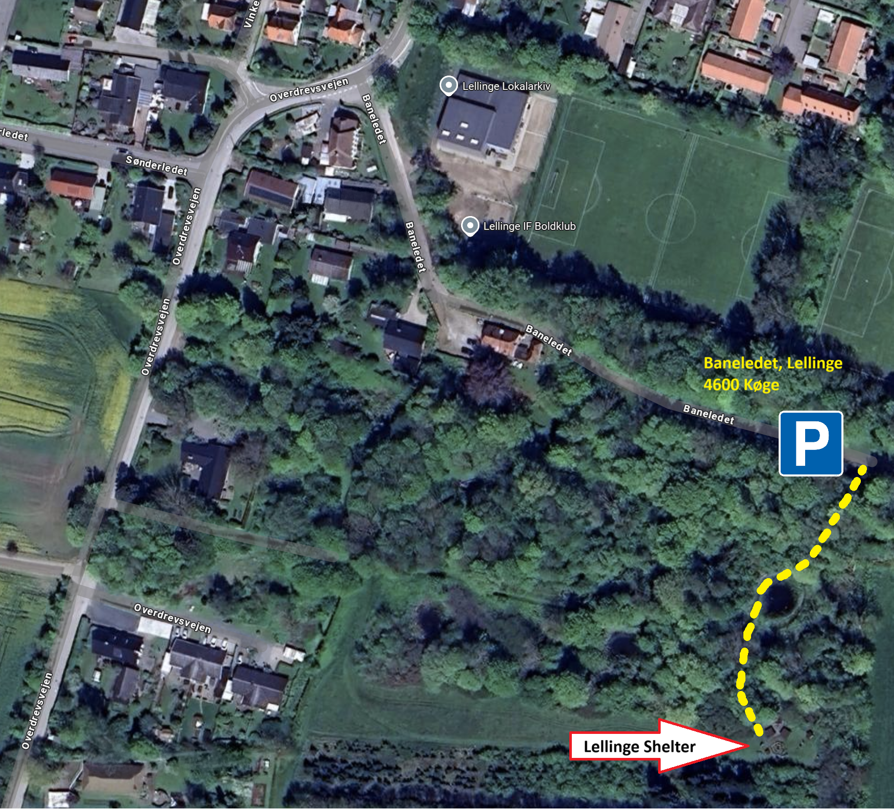
- Coming from Køge (going east to west) after 6 km. you could take a small detour in the village of Lelling and visit the local shelter. It has primitive toilets, but NO water. Also, you need to book in advance from this website and pay 100 kr. The coordinates are ‘N 55 27.776, E 12 06.593’
- After 11 km. you can find a free of charge shelter with primitive toilets and water available. “Spanager Naturlegeplads” at coordinates ‘N 55 28.759, E 012 03.179’
- After 33 km. you will find a rather wonderfully located shelter overlooking Haraldsted Lake. There are no nearby toilets or water, though, and while it is free of charge, it is also only available on a first come, first serve basis. Coordinates are ‘N 55 28.974, E 11 49.150’
- After 38 km. there is another nice shelter close to Haraldsted Lake. You can book it for free at this website. There are water and toilets nearby. Coordinates are ‘N 55 29.109, E 011 45.012
SHOPPING
There are plenty of options in the two towns, Køge and Ringsted, at the start/end of the trail.
En route, you can find a super market in the village of Lellinge after 6 km. (going east to west). Coordinates are ‘N 55 28.005, E 12 06.669’
There are also some options after 20 km. at Corona Camping and the lovely nearby pancake shop and Old Tea House. Coordinates are ‘N 55 27.920, E 011 56.630’
There is a well stocked gas station after 30 km. Coordinates are ‘N 55 29.101, E 011 51.010’
WATER
- After 11 km. (going east to west) there is a water tap roughly at ‘N 55 28.759, E 012 03.179’ (look for the shelter – it’s close by)
- After 20 km. The pancake shop has a customer toilet with running water at ‘N 55 27.920, E 011 56.630’
- After 30 km. the gas station has a toilet with running water at ‘N 55 29.101, E 011 51.010’
- After 38 km. there are toilets with running water at ‘N 55 29.109, E 011 45.012
TOILETS
- After 11 km. (going east to west) there is a primitive toilet at ‘N 55 28.759, E 012 03.179’ (look for the shelter – it’s close by)
- After 20 km. Both the campsite and the pancake shop have toilets at ‘N 55 27.920, E 011 56.630’
- After 30 km. there’s a toilet at the gas station at ‘N 55 29.101, E 011 51.010’
- After 33 km. there are very nice toilets available at ‘N 55 29.109, E 011 45.012‘
You now know all there is to know, and it’s time to click a button to either my blog or my video on the Ringsted Oplevelsessti.